The Altai State University Space Monitoring Center forecasts emergencies in the region
 On the eve of Cosmonautics Day, Yegor Mordvin, an employee of the Center, told us about how space monitoring is carried out and how it helps society.
- Why did you become interested in space monitoring?
- I became interested in it while studying at our university at the Faculty of Physics and Technology. Working with satellite data was the topic of my graduation work. After getting my bachelor's degree in 2007, I followed this direction and soon came to work at the Center for Space Monitoring.
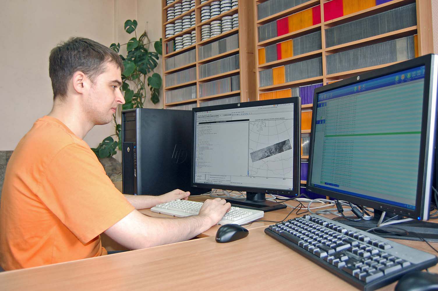
- Tell us about the Center.
- The Space Monitoring Center is a joint project of the Regional State Institution "Management for the provision of measures in the field of civil defense, emergencies and fire safety in Altai Krai" and scientists of Altai State University with the support of the governor and the government of the region. On January 17, 2002, the first reception of satellite information took place in the monitoring department. This date became the starting point of his work.
Our task is to study the state of the land surface and its atmosphere for emergencies. Let us take a wildfire as an example. If there is a wildfire somewhere, then with the help of remote sensing it is possible to determine the place of the fire, its strength and possible impact on the nearest territories.
- What emergencies are typical of Altai Krai?
- First of all, these are wildfires. We have been monitoring these events from the first half of April until the formation of a stable snow cover in the fall. The record period for the number of fires detected is the first half of May. More than 1000 events can be detected per day. This is primarily due to agricultural burns. A report on the results of satellite imagery is formed already after 30 minutes after the satellite's flight over the territory of Altai Krai and is sent to the Emergency Department, as well as the Emergency Management Center for Crisis Situations.
The second task facing the Center is to support the flood situation. Here, using satellite data, the amount of precipitation, the thickness of the snow, and the air temperature are determined.
As you know, the flood in Altai Krai takes place in two stages. The first one we can observe now is the end of March and the beginning of April. The danger is that if the snow melts too quickly or an ice jam forms in the river bed, then the river overflows its banks and can flood the nearest settlements. Thanks to space photography, you can tell exactly where such events are taking place. This data is very helpful for rescuers.
The second stage of the flood begins at the end of May and lasts until mid-July. It is associated with the descent of water from glaciers located on the territory of the Altai Republic. Sometimes this event is superimposed on heavy rainfall in the Altai foothills.
Fortunately, such events only happen every three to four years. Remote sensing just allows predicting the next flood and warn people about it. For example, if there was a heavy downpour in the foothills at night, then in a day or two this water may be with us.
- Where else is space monitoring used?
- Methods of remote sensing are used in mapping. They are also useful in climate change research. For example, to identify the concentration of greenhouse gases in the atmosphere or when changing the area of ice in the Arctic Ocean.
In recent years, satellite data have been actively used in agriculture. They provide information on the condition of vegetation, air temperature, soil moisture, precipitation, and other climatic parameters that affect plant development. Work is underway to assess the yield using satellite imagery data.
- How is remote sensing carried out?
- While in orbit, the satellite device registers the radiation that comes from the Earth's surface. This can be either the intrinsic radiation of the surface, for example, a fire or artificial light, or the solar radiation reflected from the surface. Some devices work at night and can register moonlight reflected from the Earth's surface or man-made radiation, such as night illumination of a city.
However, when passing through the atmosphere, the signal is distorted, as if you are watching an old TV. This can be caused by atmospheric aerosols, water vapor, cloudiness, fog, etc. From the received signal, scientists determine what is happening on the planet's surface and in the atmosphere.
In our Center, satellite data are recorded using a receiving station, which is located on the roof of the main building of AltSU. On a regular basis, we work with four satellites, which allows us to see the territory of Altai Krai six to eight times during the day and the same amount at night.
- What territories does the Center study?
- We are engaged in monitoring Altai Krai and adjacent territories, such as the Altai Republic, Novosibirsk and Kemerovo Oblasts, as well as the Republic of Kazakhstan. Events occurring in the neighboring territories can provoke an emergency on our territory. For example, a west wind can bring us a fire that occured in Kazakhstan.
- What are the advantages of space monitoring in comparison with ground-based research?
- Space sensing allows covering a large area. Imagine that the Center had a task of measuring the temperature of the surface air layer. You can do this using weather stations. But if we want to conduct research in Barnaul, we will find that at three points - the airport, Scientific Campus and Upland Park – the temperatures are completely different. In this case, the weather stations will have to be installed very close to each other. As you can imagine, this is not only inconvenient, but also expensive. And if you take Charyshsky District, do you really have to drag all the equipment directly into the mountains? Of course not. Therefore, space monitoring helps out here.
However, this approach has several nuances. The device, which is located on the satellite, does not come into contact with the object of observation itself, but measures only the signal passing through the atmosphere. It's like trying to identify a person by their silhouette in fog or smoke. Therefore, ground based observations provide more accurate data than space observations.
- I remember the terrible Siberian fires of 2019. How does the Center work in the face of such major incidents?
- In case of large-scale emergencies in Altai Krai, the Center's employees work not only during the day, but also at night. This requires operational processing and analysis of night satellite data. For example, this happened in the fall of 2010, when the village of Nikolaevka was damaged by fire. In 2019, there was no such risk, however, using satellite observations, we performed an estimate of the aerosol content in the atmosphere, which directly indicates the quality of the inhaled air. We passed this information to the Crisis Management Center of the Ministry for Emergencies. Then the specialists worked on the basis of our data.
- What causes the occurrence of emergencies? Do they occur according to the laws of nature or due to human intervention?
- Most of the crisis situations occur for natural reasons, but there is also a human factor. If we take an approaching hurricane as an example, we will immediately understand that it appears regardless of man and cannot be influenced in any way. Or the last frost that destroyed half of the crops - who is to blame it? Only nature itself.
But there are also a number of events for which man is responsible. These are numerous fires. For example, when people go for a picnic and make fires. A particular danger arises in the second half of August and early September, when the grass begins to dry out and is highly flammable. One unextinguished fire or an abandoned cigarette butt can lead to a large fire.
Julia Dilman, “For Science”